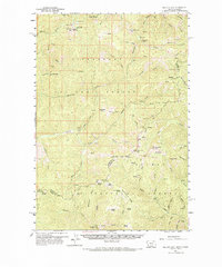
1960 Map of Piquett Mountain
USGS Topo · Published 1985About this map
Bitterroot National Forest and Salmon National Forest converge along this high-altitude border, where the state line follows the dramatic crest of the Continental Divide between Montana Idaho. The landscape is defined by its deep drainages and sharp peaks, featuring early forest infrastructure like the Piquett Mtn Lookout and remote outposts such as Henderson Cabin. Evidence of human activity is primarily found in the extractive sites scattered across the ridges, including an Open Pit Mine and various Prospects and Tailings along Hughes Creek.
Find a feature on this map
86 named features on this map. Tap any name to fly to it.
Don’t see what you’re looking for? This feature index may not catch every label — zoom into the map to look around manually.
Map Details
Editions of this 1960 Piquett Mountain Map
3 editions found
Other maps of this area

1955 · Dillon
USGS Topo · 1:250,000

1956 · Elk City
USGS Topo · 1:250,000

1957 · Dillon
USGS Topo · 1:250,000

1958 · Dillon
USGS Topo · 1:250,000

1960 · Elk City
USGS Topo · 1:250,000

1960 · Painted Rocks Lake
USGS Topo · 1:62,500

1960 · Ulysses Mtn
USGS Topo · 1:62,500

1960 · Shoup
USGS Topo · 1:62,500

1960 · Piquett Mountain
USGS Topo · 1:62,500

1962 · Dillon
USGS Topo · 1:250,000