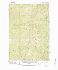
1960 Map of Piquett Mtn
USGS Topo · Published 1985About this map
The high alpine country of the Bitterroot Range dominates this 1960s survey, straddling the state line between Montana and Idaho. Significant vertical relief is anchored by Piquett Mtn and Allan Mtn, which define the drainage basins for Hughes Creek and Wiles Creek. The map documents a landscape of resource extraction and seasonal habitation, evidenced by the Open Pit Mine and scattered tailings piles along the creek beds. Remote outposts like Henderson Cabin and Salzer Bar provide specific points of interest for local historians, while the inclusion of the Lookout VABM 8831 at Piquett Peak speaks to the area's fire management infrastructure within the Bitterroot National Forest and Salmon National Forest. The network of jeep trails and specialized terrain features, such as Irishmans Rock and Butcherknife Ridge, offers a detailed view of this wilderness before modern development altered these traditional access routes.
Find a feature on this map
69 named features on this map. Tap any name to fly to it.
Don’t see what you’re looking for? This feature index may not catch every label — zoom into the map to look around manually.
Map Details
Editions of this 1960 Piquett Mtn Map
3 editions found
Other maps of this area

1955 · Dillon
USGS Topo · 1:250,000

1956 · Elk City
USGS Topo · 1:250,000

1957 · Dillon
USGS Topo · 1:250,000

1958 · Dillon
USGS Topo · 1:250,000

1960 · Elk City
USGS Topo · 1:250,000

1960 · Painted Rocks Lake
USGS Topo · 1:62,500

1960 · Ulysses Mtn
USGS Topo · 1:62,500

1960 · Shoup
USGS Topo · 1:62,500

1960 · Piquett Mountain
USGS Topo · 1:62,500

1962 · Dillon
USGS Topo · 1:250,000