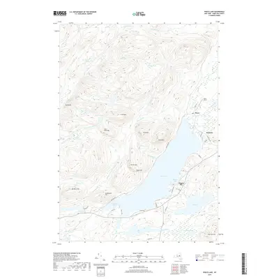
2019 Map of Piseco Lake
USGS Topo · Published 2019About this map
Piseco Lake and its surrounding high-elevation peaks dominate this Hamilton County landscape in the late 2010s. The settlement of Piseco serves as a focal point near the northern shore, situated where Fall Stream enters the lake near the Piseco Airport. Further south along the shoreline, the community at Higgins Bay marks a cluster of local development. The terrain is defined by dramatic elevations such as Echo Cliff, Piseco Mtn, and Panther Mtn, which overlook a complex network of smaller water bodies including Spy Lake, White Birch Lake, and the Twin Lakes.
Find a feature on this map
53 named features on this map. Tap any name to fly to it.
Don’t see what you’re looking for? This feature index may not catch every label — zoom into the map to look around manually.
Map Details
Editions of this 2019 Piseco Lake Map
This is the sole edition of this map. No revisions or reprints were ever made.
Other maps of this area

1899 · Indian Lake
USGS Topo · 1:62,500

1900 · Canada Lake
USGS Topo · 1:62,500

1902 · Indian Lake
USGS Topo · 1:62,500

1903 · West Canada Lakes
USGS Topo · 1:62,500

1904 · Piseco Lake
USGS Topo · 1:62,500

1906 · Piseco Lake
USGS Topo · 1:62,500

1907 · Lake Pleasant
USGS Topo · 1:62,500

1908 · Piseco Lake
USGS Topo · 1:62,500

1950 · Utica
USGS Topo · 1:250,000

1954 · Lake Pleasant
USGS Topo · 1:62,500