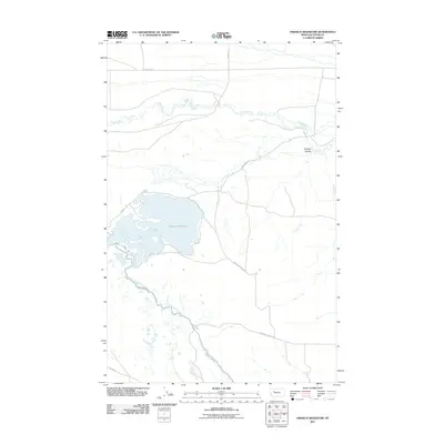
2011 Map of Pishkun Reservoir
USGS Topo · Published 2011About this map
Pishkun Reservoir dominates this high-plains landscape in Teton County, serving as a critical node in the regional irrigation infrastructure. The 2011 survey reveals a complex water management system, defined by the winding course of the Sun River Slope Canal and the Pishkun Canal Rd that tracks its path. This network reflects the vital role of water engineering in sustaining the agricultural economy of the Montana benchlands.
Find a feature on this map
12 named features on this map. Tap any name to fly to it.
Don’t see what you’re looking for? This feature index may not catch every label — zoom into the map to look around manually.
Map Details
Editions of this 2011 Pishkun Reservoir Map
This is the sole edition of this map. No revisions or reprints were ever made.
Other maps of this area

1903 · Saypo
USGS Topo · 1:125,000

1920 · Choteau
USGS Topo · 1:125,000

1955 · Choteau
USGS Topo · 1:250,000

1957 · Choteau
USGS Topo · 1:250,000

1958 · Choteau
USGS Topo · 1:250,000

1958 · Lake Theboe
USGS Topo · 1:24,000

1958 · Barr Creek
USGS Topo · 1:24,000
1958 · Split Rock Lake
USGS Topo · 1:24,000

1960 · Bynum
USGS Topo · 1:62,500

1960 · Gilman
USGS Topo · 1:62,500