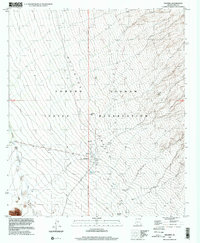
1996 Map of Pisinimo
USGS Topo · Published 2001About this map
Pisinimo serves as a primary settlement within the Tohono O'Odham Indian Reservation, situated near the convergence of desert drainages. This late-twentieth-century study of the Arizona desert landscape reveals a network of seasonal watercourses like Gu Vo Wash and Simon Wash that define the valley's character. The map identifies specific communal sites including a Cemetery and Sewage Disposal Ponds near the main village, alongside historic markers of human occupation at Vlason Chin (Site) and Hali Murk (Site). Surveyed at the intersection of the Gila And Salt River Meridian, the terrain transitions from the lowlands into the elevated reaches of the Quijotoa range, capturing a transition between ancient habitation sites and modern reservation infrastructure.
Find a feature on this map
18 named features on this map. Tap any name to fly to it.
Don’t see what you’re looking for? This feature index may not catch every label — zoom into the map to look around manually.
Map Details
Editions of this 1996 Pisinimo Map
This is the sole edition of this map. No revisions or reprints were ever made.
Other maps of this area

1953 · Ajo
USGS Topo · 1:250,000

1954 · Sonoyta
USGS Topo · 1:250,000

1957 · Ajo
USGS Topo · 1:250,000

1958 · Ajo
USGS Topo · 1:250,000

1962 · Ajo
USGS Topo · 1:250,000

1963 · Ajo
USGS Topo · 1:250,000

1963 · Kom Vo
USGS Topo · 1:62,500

1963 · Gu Oidak
USGS Topo · 1:62,500

1963 · Quijotoa Mts
USGS Topo · 1:62,500

1963 · Pisinimo
USGS Topo · 1:62,500
Featured Places
- Viason Chin, Pisinemo District
- Peach Pu, Pisinemo District
- Pisinimo, Pisinemo District
- Hali Murk, Pisinemo District
- Pisinemo District, AZ