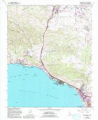
1965 Map of Pismo Beach
USGS Topo · Published 1994About this map
The coastal communities of San Luis Obispo County are captured during a period of transition, showing the shoreline from Avila Beach to Grover Beach. The landscape is defined by the sharp contrast between the steep canyons of the Irish Hills, such as Castro Canyon and Squire Canyon, and the developing coastal plain. Transportation infrastructure is prominent, with the Southern Pacific railroad and major roads like Los Osos Valley Rd and Price Canyon Road connecting the agricultural interior to the Pacific.
Find a feature on this map
47 named features on this map. Tap any name to fly to it.
Don’t see what you’re looking for? This feature index may not catch every label — zoom into the map to look around manually.
Map Details
Editions of this 1965 Pismo Beach Map
4 editions found
Other maps of this area

1897 · Port Harford
USGS Topo · 1:62,500

1897 · San Luis Obispo
USGS Topo · 1:62,500

1897 · Cayucos
USGS Topo · 1:62,500

1897 · Arroyo Grande
USGS Topo · 1:62,500

1900 · San Luis
USGS Topo · 1:125,000

1937 · Cayucos
USGS Topo · 1:62,500

1941 · Port San Luis
USGS Topo · 1:62,500

1942 · San Luis Obispo
USGS Topo · 1:62,500

1942 · Arroyo Grande
USGS Topo · 1:62,500

1943 · Cayucos
USGS Topo · 1:62,500