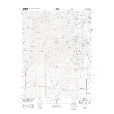
2013 Map of Pitkin
USGS Topo · Published 2013About this map
Pitkin sits at the junction of Quartz Cr and several high-elevation gulches, serving as a primary hub for this section of the Gunnison National Forest. The landscape is defined by its mining-era legacy and natural thermal features, most notably Waunita Hot Springs and Lower Waunita Hot Springs in the southern portion of the quadrangle. The map details a transition from the structured street grid of the Pitkin townsite—with names like Main St and Union St—to the surrounding peaks like Islet Mountain and Lookout Mountain. Local history and genealogy are anchored by the Pitkin Cem and Ohio City Cem, while recreational use is evident through the Pitkin Campground and numerous forest trails. A dense network of forest roads, including Co Road 771 and Co Road 76, connects the old settlements of Ohio and Pitkin through steep terrain marked by names like Last Chance Gulch and Revenue Gulch, reflecting the region's historical prospecting activity.
Find a feature on this map
92 named features on this map. Tap any name to fly to it.
Don’t see what you’re looking for? This feature index may not catch every label — zoom into the map to look around manually.
Map Details
Editions of this 2013 Pitkin Map
This is the sole edition of this map. No revisions or reprints were ever made.
Other maps of this area

1940 · Garfield
USGS Topo · 1:62,500

1941 · Pitkin
USGS Topo · 1:62,500

1945 · Pitkin
USGS Topo · 1:62,500

1945 · Garfield
USGS Topo · 1:62,500

1956 · Montrose
USGS Topo · 1:250,000

1959 · Montrose
USGS Topo · 1:250,000

1960 · Montrose
USGS Topo · 1:250,000

1962 · Doyleville
USGS Topo · 1:24,000

1962 · Houston Gulch
USGS Topo · 1:24,000
1964 · Pitkin
USGS Topo · 1:24,000