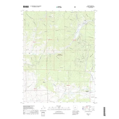
2019 Map of Pitkin
USGS Topo · Published 2019About this map
Pitkin and the surrounding high-country terrain of Gunnison National Forest define this landscape along the upper reaches of Quartz Cr. This high-altitude region is shaped by steep drainage systems like Dutch Flats Gulch and Armstrong Canyon, reflecting a history of mountain transit and early settlement. The map reveals a network of winter recreation trails, including the Comanche Gulch Snowmobile/Ski trail and the Waunita Pass Sno route, which follow the historical paths carved by early miners and ranchers. To the south, Waunita Hot Springs and the nearby Hot Springs Reservoir indicate the geothermal activity that once made this area a destination for those seeking the restorative waters of the Rockies. Genealogists will find the Pitkin Cem and Ohio City Cem well-documented near the banks of local creeks.
Find a feature on this map
76 named features on this map. Tap any name to fly to it.
Don’t see what you’re looking for? This feature index may not catch every label — zoom into the map to look around manually.
Map Details
Editions of this 2019 Pitkin Map
This is the sole edition of this map. No revisions or reprints were ever made.
Other maps of this area

1940 · Garfield
USGS Topo · 1:62,500

1941 · Pitkin
USGS Topo · 1:62,500

1945 · Pitkin
USGS Topo · 1:62,500

1945 · Garfield
USGS Topo · 1:62,500

1956 · Montrose
USGS Topo · 1:250,000

1959 · Montrose
USGS Topo · 1:250,000

1960 · Montrose
USGS Topo · 1:250,000

1962 · Doyleville
USGS Topo · 1:24,000

1962 · Houston Gulch
USGS Topo · 1:24,000
1964 · Pitkin
USGS Topo · 1:24,000