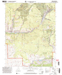
2001 Map of Pitkin
USGS Topo · Published 2004About this map
Pitkin serves as the primary settlement in this high-altitude landscape of Gunnison County, where the legacy of extraction and recreation meet. The terrain is deeply incised by a network of gulches including Schoolhouse Gulch, Powderhouse Gulch, and Limekiln Gulch, names that suggest the early industrial and civic infrastructure of the mining era. Evidence of this heritage is visible at the Carter Mine and Raymond Mine near the northern edge, as well as the Campbird Mine further east.
Find a feature on this map
62 named features on this map. Tap any name to fly to it.
Don’t see what you’re looking for? This feature index may not catch every label — zoom into the map to look around manually.
Map Details
Editions of this 2001 Pitkin Map
This is the sole edition of this map. No revisions or reprints were ever made.
Other maps of this area

1940 · Garfield
USGS Topo · 1:62,500

1941 · Pitkin
USGS Topo · 1:62,500

1945 · Pitkin
USGS Topo · 1:62,500

1945 · Garfield
USGS Topo · 1:62,500

1956 · Montrose
USGS Topo · 1:250,000

1959 · Montrose
USGS Topo · 1:250,000

1960 · Montrose
USGS Topo · 1:250,000

1962 · Doyleville
USGS Topo · 1:24,000

1962 · Houston Gulch
USGS Topo · 1:24,000
1964 · Pitkin
USGS Topo · 1:24,000