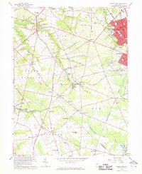
1967 Map of Pitman West
USGS Topo · Published 1969About this map
Mullica Hill serves as a prominent focal point in this late-1960s landscape, situated at the confluence of Raccoon Creek and several early roadways. The map illustrates a rural New Jersey in transition, where established agricultural areas meet the expanding boroughs of Pitman and Glassboro. To the south, the terrain becomes increasingly marshy, defined by the expansive Elephant Swamp and numerous small water bodies like Loggerhead Pond and Garrison Lake.
Find a feature on this map
96 named features on this map. Tap any name to fly to it.
Don’t see what you’re looking for? This feature index may not catch every label — zoom into the map to look around manually.
Map Details
Editions of this 1967 Pitman West Map
3 editions found
Other maps of this area

1890 · Salem
USGS Topo · 1:62,500

1890 · Glassboro
USGS Topo · 1:62,500

1891 · Philadelphia
USGS Topo · 1:62,500

1894 · Chester
USGS Topo · 1:62,500

1894 · Philadelphia
USGS Topo · 1:62,500

1896 · Philadelphia
USGS Topo · 1:62,500

1896 · Chester
USGS Topo · 1:62,500

1898 · Salem
USGS Topo · 1:62,500

1898 · Glassboro
USGS Topo · 1:62,500

1898 · Chester
USGS Topo · 1:62,500