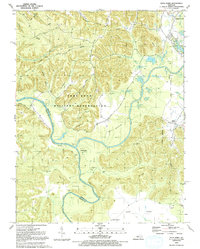
1991 Map of Pitts Point
USGS Topo · Published 1992About this map
Fort Knox Military Reservation dominates this 1991 landscape, covering the rugged interior hills and ridges of Bullitt and Hardin counties. The map captures a complex intersection of military land use and rural heritage, where family cemeteries like Anderson Cem and Holsclaw Cem remain preserved within federal boundaries. The terrain is defined by the winding course of the Salt River and its confluence with the Rolling Fork, creating fertile bottomlands at Atherton Flats.
Find a feature on this map
74 named features on this map. Tap any name to fly to it.
Don’t see what you’re looking for? This feature index may not catch every label — zoom into the map to look around manually.
Map Details
Editions of this 1991 Pitts Point Map
This is the sole edition of this map. No revisions or reprints were ever made.
Other maps of this area

1907 · Louisville
USGS Topo · 1:62,500

1909 · Kosmosdale
USGS Topo · 1:48,000

1912 · Kosmosdale
USGS Topo · 1:62,500

1936 · Vine Grove
USGS Topo · 1:62,500

1943 · Vine Grove
USGS Topo · 1:62,500

1946 · Pitts Point
USGS Topo · 1:24,000

1946 · Fort Knox
USGS Topo · 1:24,000

1946 · Colesburg
USGS Topo · 1:24,000

1946 · Vine Grove
USGS Topo · 1:24,000

1946 · Vine Grove
USGS Topo · 1:62,500