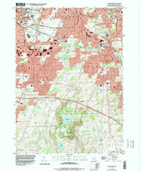
1994 Map of Pittsford
USGS Topo · Published 2000About this map
Mendon Ponds County Park dominates the southern landscape of this 1994 survey, showcasing a complex glacial geography featuring Devils Bathtub, Deep Pond, and Quaker Pond. To the north, the historic Erie Canalway cuts through the village of Pittsford, flanked by the New York Central railroad and a burgeoning suburban network. The map reveals a dense concentration of educational and institutional landmarks, including Nazareth College of Rochester, St John Fisher College, and the sprawling Rochester State Hospital complex near West Brighton. Notable for local historians, the sheet preserves the locations of early local sites like the Pioneer Burying Ground alongside mid-century infrastructure like the New York State Thruway and numerous radio towers. This transition from natural parkland to academic and industrial corridors reflects the suburban growth of Monroe County in the late twentieth century.
Find a feature on this map
75 named features on this map. Tap any name to fly to it.
Don’t see what you’re looking for? This feature index may not catch every label — zoom into the map to look around manually.
Map Details
Editions of this 1994 Pittsford Map
This is the sole edition of this map. No revisions or reprints were ever made.
Other maps of this area

1895 · Rochester
USGS Topo · 1:62,500

1898 · Rochester
USGS Topo · 1:62,500

1900 · Macedon
USGS Topo · 1:62,500

1900 · Canandaigua
USGS Topo · 1:62,500

1901 · Honeoye
USGS Topo · 1:62,500

1903 · Canandaigua
USGS Topo · 1:62,500

1904 · Honeoye
USGS Topo · 1:62,500

1912 · Rochester
USGS Topo · 1:62,500

1920 · Rochester
USGS Topo · 1:62,500

1931 · Mendon Ponds
USGS Topo · 1:24,000