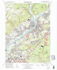
1994 Map of Pittston
USGS Topo · Published 1995About this map
The Susquehanna River and Lackawanna River converge at the heart of this industrial and residential landscape, marking the historic anthracite coal region of northeastern Pennsylvania. This mid-1990s record captures the dense urbanization of Pittston, West Pittston, and Duryea, where the valley floor is a complex network of rail lines and early 20th-century neighborhoods. Significant local landmarks include the Wyoming Monument and the campus of Wyoming Seminary, reflecting the area's deep colonial and educational roots.
Find a feature on this map
102 named features on this map. Tap any name to fly to it.
Don’t see what you’re looking for? This feature index may not catch every label — zoom into the map to look around manually.
Map Details
Editions of this 1994 Pittston Map
This is the sole edition of this map. No revisions or reprints were ever made.
Other maps of this area

1889 · Scranton
USGS Topo · 1:62,500

1891 · Wilkesbarre
USGS Topo · 1:62,500

1891 · Scranton
USGS Topo · 1:62,500

1893 · Pittston
USGS Topo · 1:62,500

1893 · Scranton
USGS Topo · 1:62,500

1894 · Wilkesbarre
USGS Topo · 1:62,500

1922 · Stoddartsville
USGS Topo · 1:62,500

1924 · Stoddartsville
USGS Topo · 1:62,500

1943 · Scranton
USGS Topo · 1:125,000

1943 · Stoddartsville
USGS Topo · 1:62,500