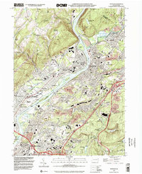
1999 Map of Pittston
USGS Topo · Published 2002About this map
The confluence of the Susquehanna River and the Lackawanna River forms the industrial and geographic heart of this Pennsylvania landscape. Dominated by the tight cluster of riverfront towns including West Pittston, Duryea, and Exeter, the map reveals a dense network of neighborhoods and infrastructure forged by the regional coal economy. Heavy industry and transit are evident at the extensive Pittston Yards and the sprawling footprint of the Pocono Downs Racetrack.
Find a feature on this map
88 named features on this map. Tap any name to fly to it.
Don’t see what you’re looking for? This feature index may not catch every label — zoom into the map to look around manually.
Map Details
Editions of this 1999 Pittston Map
This is the sole edition of this map. No revisions or reprints were ever made.
Other maps of this area

1889 · Scranton
USGS Topo · 1:62,500

1891 · Wilkesbarre
USGS Topo · 1:62,500

1891 · Scranton
USGS Topo · 1:62,500

1893 · Pittston
USGS Topo · 1:62,500

1893 · Scranton
USGS Topo · 1:62,500

1894 · Wilkesbarre
USGS Topo · 1:62,500

1922 · Stoddartsville
USGS Topo · 1:62,500

1924 · Stoddartsville
USGS Topo · 1:62,500

1943 · Scranton
USGS Topo · 1:125,000

1943 · Stoddartsville
USGS Topo · 1:62,500