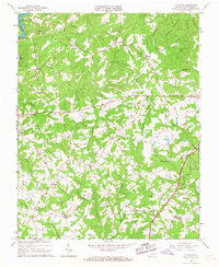
1964 Map of Pittsville
USGS Topo · Published 1967About this map
Leesville Lake anchors the northwestern corner of this landscape, where the Pigg River feeds into the reservoir near Ridgeway. The surrounding Pittsylvania County terrain is defined by a dense network of watercourses including Whitethorn Creek, Fryingpan Creek, and Cherrystone Creek, which carve through the wooded hills. Small rural hubs like Pittsville, Toshes, and Climax are connected by winding secondary roads, often marked by community landmarks such as Climax Sch and Watson Level Ch.
Find a feature on this map
38 named features on this map. Tap any name to fly to it.
Don’t see what you’re looking for? This feature index may not catch every label — zoom into the map to look around manually.
Map Details
Editions of this 1964 Pittsville Map
2 editions found
Other maps of this area

1890 · Roanoke
USGS Topo · 1:125,000

1891 · Roanoke
USGS Topo · 1:125,000

1892 · Lynchburg
USGS Topo · 1:125,000

1921 · Chatham
USGS Topo · 1:48,000

1922 · Callands
USGS Topo · 1:48,000

1923 · Chatham
USGS Topo · 1:62,500

1924 · Callands
USGS Topo · 1:62,500

1944 · Callands
USGS Topo · 1:62,500

1947 · Roanoke
USGS Topo · 1:250,000

1951 · Moneta
USGS Topo · 1:62,500