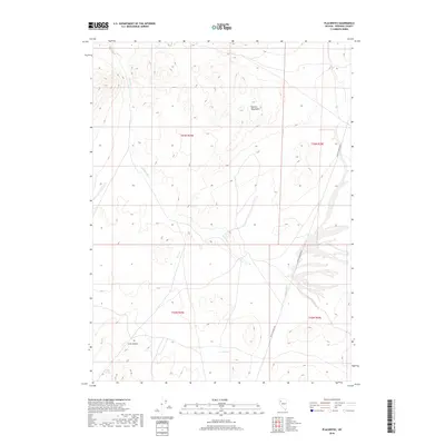
2018 Map of Placerites
USGS Topo · Published 2018About this map
The Kamma Mountains define the high desert topography of this Pershing County landscape, where water sources were essential for survival and transit. Named water features like Judges Springs, Corral Spring, and Outlaw Spring suggest a history of seasonal usage and livestock management in an otherwise arid basin. The drainage of Rabbithole Cr and Cow Cr cuts through the terrain, leading toward Cow Canyon in the southwestern portion of the map. Modern access is marked by Seven Troughs Rd, a route that skirts the eastern foothills. This map documents the persistent land divisions of the Public Land Survey System, including t33n r29e and t32n r30e, illustrating how historical township and range boundaries continue to organize the remote Nevada interior.
Find a feature on this map
12 named features on this map. Tap any name to fly to it.
Don’t see what you’re looking for? This feature index may not catch every label — zoom into the map to look around manually.
Map Details
Editions of this 2018 Placerites Map
This is the sole edition of this map. No revisions or reprints were ever made.
Other maps of this area

1931 · Lovelock
USGS Topo · 1:250,000

1935 · Lovelock
USGS Topo · 1:250,000

1955 · Lovelock
USGS Topo · 1:250,000

1959 · Lovelock
USGS Topo · 1:250,000
1981 · Sawtooth Knob
USGS Topo · 1:24,000

1981 · Dead Horse Canyon NE
USGS Topo · 1:24,000

1981 · Scossa
USGS Topo · 1:24,000

1981 · Placerites
USGS Topo · 1:24,000
1981 · Poker Brown Gap
USGS Topo · 1:24,000
1981 · Sulphur
USGS Topo · 1:24,000