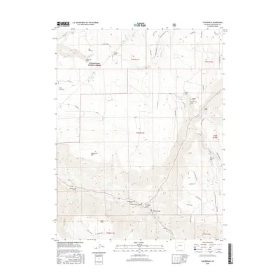
2016 Map of Placerville
USGS Topo · Published 2016About this map
Placerville sits at the confluence of Leopard Cr and the San Miguel River, serving as a focal point for this high-elevation landscape in the mid-2010s. The terrain is defined by dramatic elevation changes between the river valley and the expansive plateaus of Iron Springs Mesa, Specie Mesa, and Hastings Mesa. The map records a complex network of ranch and access roads, such as Goodenough and Old Elam Ranch Rd, that navigate the deep cuts of Specie Creek Canyon and Leopard Creek Canyon. To the north, the Uncompahgre National Forest encompasses landmarks like The Flatiron and McKenzie Point. Geothermal activity is noted at Lemon Hot Spring, while numerous water sources like Saint Joe Spring and Galloway Spring underscore the importance of water rights in this arid San Miguel County environment.
Find a feature on this map
62 named features on this map. Tap any name to fly to it.
Don’t see what you’re looking for? This feature index may not catch every label — zoom into the map to look around manually.
Map Details
Editions of this 2016 Placerville Map
This is the sole edition of this map. No revisions or reprints were ever made.
Other maps of this area

1897 · Telluride
USGS Topo · 1:62,500

1904 · Telluride
USGS Topo · 1:62,500

1909 · Montrose
USGS Topo · 1:125,000

1911 · Montrose
USGS Topo · 1:125,000

1945 · Durango
USGS Topo · 1:250,000

1953 · Placerville
USGS Topo · 1:24,000
1953 · Gray Head
USGS Topo · 1:24,000

1953 · Little Cone
USGS Topo · 1:24,000

1953 · Durango
USGS Topo · 1:250,000

1954 · Durango
USGS Topo · 1:250,000