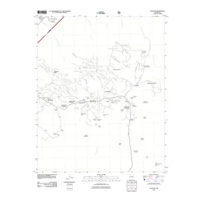
2011 Map of Placitas
USGS Topo · Published 2011About this map
Placitas and its surrounding homesteads occupy the northern foothills of the Sandia Mountains, where traditional land use and modern residential expansion meet. The landscape is defined by its reliance on water and mineral resources, evidenced by the Casa Acequia and a high concentration of mining claims including the Victo Group, San Jose Group, and the Montezuma Mine. These sites sit alongside more recent developments like The Overlook and Puesta Del Sol. The map documents the intricate network of local drainage, such as Las Huertas Creek and Arroyo del Oso, which have historically shaped settlement patterns in this part of Sandoval County. Genealogists may find value in the locations of Placitas Cemetery and Algodones Cemetery, while researchers of the ranching era can trace the grounds of the Diamond-Tail Ranch and El Rancho de San Francisco near the eastern edge of the survey.
Find a feature on this map
74 named features on this map. Tap any name to fly to it.
Don’t see what you’re looking for? This feature index may not catch every label — zoom into the map to look around manually.
Map Details
Editions of this 2011 Placitas Map
This is the sole edition of this map. No revisions or reprints were ever made.
Other maps of this area

1888 · Bernalillo
USGS Topo · 1:125,000

1889 · Albuquerque
USGS Topo · 1:125,000

1892 · San Pedro
USGS Topo · 1:125,000

1893 · Albuquerque
USGS Topo · 1:125,000

1934 · Alameda
USGS Topo · 1:24,000

1938 · Albuquerque
USGS Topo · 1:62,500

1954 · Sandia Crest
USGS Topo · 1:24,000

1954 · Alameda
USGS Topo · 1:24,000

1954 · San Felipe Pueblo
USGS Topo · 1:24,000

1954 · Placitas
USGS Topo · 1:24,000
Featured Places
- Puesta Del Sol, NM
- Sundance Mesa, NM
- Ranchos des Placitas, NM
- Village de las Huertas, NM
- Diamond Tail Ranch, NM