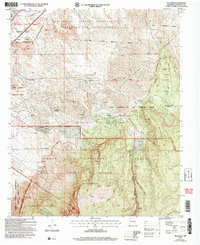
2006 Map of Placitas
USGS Topo · Published 2007About this map
Placitas sits at the foot of the northern Sandia Mountain range, where the high desert meets the wooded slopes of the Cibola National Forest. The landscape is a complex patchwork of land grants and tribal territories, including the San Felipe Indian Reservation and the San Antonio de las Huertas Grant. This geography reveals a long history of water management and resource extraction, with numerous drainage systems like Arroyo de las Huertas and evidence of small-scale mining at the Strip Mine and Coal Mine south of Placitas Homesteads.
Find a feature on this map
58 named features on this map. Tap any name to fly to it.
Don’t see what you’re looking for? This feature index may not catch every label — zoom into the map to look around manually.
Map Details
Editions of this 2006 Placitas Map
This is the sole edition of this map. No revisions or reprints were ever made.
Other maps of this area

1888 · Bernalillo
USGS Topo · 1:125,000

1889 · Albuquerque
USGS Topo · 1:125,000

1892 · San Pedro
USGS Topo · 1:125,000

1893 · Albuquerque
USGS Topo · 1:125,000

1934 · Alameda
USGS Topo · 1:24,000

1938 · Albuquerque
USGS Topo · 1:62,500

1954 · Sandia Crest
USGS Topo · 1:24,000

1954 · Alameda
USGS Topo · 1:24,000

1954 · San Felipe Pueblo
USGS Topo · 1:24,000

1954 · Placitas
USGS Topo · 1:24,000