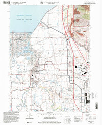
1998 Map of Plain City
USGS Topo · Published 2001About this map
Plain City and Farr West center this 1990s survey, illustrating a landscape defined by water management and expanding educational infrastructure. The massive Willard Bay Reservoir, held back by the Arthur Watkins Dam, dominates the northwestern corner alongside the Willard Bay State Park. To the south, the Weber River meanders toward its delta, feeding into a complex system of canals and drainage ditches such as Salt Creek and the North Branch Road corridor.
Find a feature on this map
69 named features on this map. Tap any name to fly to it.
Don’t see what you’re looking for? This feature index may not catch every label — zoom into the map to look around manually.
Map Details
Editions of this 1998 Plain City Map
This is the sole edition of this map. No revisions or reprints were ever made.
Other maps of this area

1954 · Whistler Canal
USGS Topo · 1:24,000

1954 · Ogden
USGS Topo · 1:250,000

1954 · Brigham City
USGS Topo · 1:250,000

1955 · Ogden
USGS Topo · 1:24,000

1955 · Plain City
USGS Topo · 1:24,000

1955 · Roy
USGS Topo · 1:24,000

1955 · Mantua
USGS Topo · 1:24,000

1955 · Plain City SW
USGS Topo · 1:24,000

1955 · Willard
USGS Topo · 1:24,000

1955 · North Ogden
USGS Topo · 1:24,000