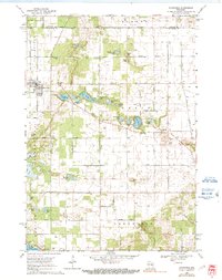
1968 Map of Plainfield
USGS Topo · Published 1991About this map
Glacial kettle lakes and small agricultural settlements define this central Wisconsin landscape during the late 1960s. The village of Plainfield serves as the primary hub, situated along the Soo Line railroad and featuring a Landing Field on its western edge. The terrain is notably dense with small bodies of water, from the larger Lake Huron and Weymouth Lake to the smaller Pumpkin Seed Lake and Fiddle Lake. This concentration of water influenced early land use, as evidenced by the distribution of family and community burial grounds such as Hillside Cem and Oasis Cem. The presence of several town halls, including one in Oasis, suggests a well-established local civic structure in the rural townships. Toward the south, the landscape transitions into the town of Hancock, where Fish Lake and the St Michael Camp Chapel mark the lakeside community.
Find a feature on this map
52 named features on this map. Tap any name to fly to it.
Don’t see what you’re looking for? This feature index may not catch every label — zoom into the map to look around manually.
Map Details
Editions of this 1968 Plainfield Map
2 editions found
Other maps of this area

1955 · Green Bay
USGS Topo · 1:250,000

1957 · Amherst
USGS Topo · 1:48,000

1957 · Whiting
USGS Topo · 1:48,000

1958 · Coloma
USGS Topo · 1:48,000

1959 · Wautoma
USGS Topo · 1:48,000

1968 · Coloma
USGS Topo · 1:24,000

1968 · Richford
USGS Topo · 1:24,000

1968 · Plainfield
USGS Topo · 1:24,000
1968 · Wautoma
USGS Topo · 1:24,000

1968 · Hancock
USGS Topo · 1:24,000