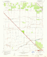
1960 Map of Plainsburg
USGS Topo · Published 1961About this map
The Southern Pacific railroad cuts a diagonal line through this San Joaquin Valley landscape, connecting the small agricultural settlements of Athlone and Minturn. To the north, Le Grand serves as a more significant hub, where the Atchison Topeka and Santa Fe railroad passes near the High Sch and Savana Sch. The terrain is defined by a series of southwest-flowing waterways, including Mariposa Creek, Deadman Creek, and Dutchman Creek, which irrigate the extensive orchards and fields characteristic of this Merced and Madera County border region. Near the village of Plainsburg, the grid of section lines and rural roads like Worden Avenue and Le Grand Road reflects a highly organized agricultural economy. Along the southern edge, the Chowchilla River and Old Chowchilla Creek meander across the flats, marking the boundary between the two counties in a period of established irrigation and rail-dependent transit.
Find a feature on this map
30 named features on this map. Tap any name to fly to it.
Don’t see what you’re looking for? This feature index may not catch every label — zoom into the map to look around manually.
Map Details
Editions of this 1960 Plainsburg Map
3 editions found
Other maps of this area

1914 · Merced
USGS Topo · 1:31,680

1915 · Owens Creek
USGS Topo · 1:31,680

1916 · Berenda
USGS Topo · 1:31,680

1917 · Merced
USGS Topo · 1:31,680

1918 · Bliss Ranch
USGS Topo · 1:31,680

1918 · Owens Creek
USGS Topo · 1:31,680

1918 · Lingard
USGS Topo · 1:31,680

1918 · Chowchilla
USGS Topo · 1:31,680

1918 · Berenda
USGS Topo · 1:31,680

1918 · Planada
USGS Topo · 1:31,680