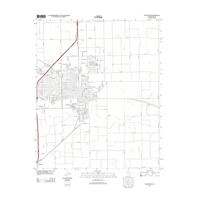
2012 Map of Plainview
USGS Topo · Published 2012About this map
Plainview Commercial Historic District anchors this 2012 survey of the Hale County seat, reflecting its role as a regional trade hub on the Texas High Plains. The map details the academic campus of Wayland Baptist Univ and the residential expansion toward Seth Ward to the northeast. Transportation and aviation infrastructure are prominent, with the Hale County Airport positioned south of the main town and the smaller Horan Airport to the east. Local history researchers will find significant genealogical value in the detailed layout of several burial grounds, including Plainview Cem, the Independent Order of Odd Fellows Cem, and the nearby Floral site. The grid of Hale County is further defined by industrial zones along Industrial Blvd and the small settlement of Furguson at the southern edge.
Find a feature on this map
74 named features on this map. Tap any name to fly to it.
Don’t see what you’re looking for? This feature index may not catch every label — zoom into the map to look around manually.
Map Details
Editions of this 2012 Plainview Map
This is the sole edition of this map. No revisions or reprints were ever made.
Other maps of this area

1954 · Plainview
USGS Topo · 1:250,000

1958 · Plainview
USGS Topo · 1:250,000

1965 · Kress West
USGS Topo · 1:24,000

1965 · Wasson
USGS Topo · 1:24,000

1965 · Plainview
USGS Topo · 1:24,000

1968 · Happy Union
USGS Topo · 1:24,000

1968 · Plainview SE
USGS Topo · 1:24,000
1968 · Hale Center
USGS Topo · 1:24,000

1968 · Aiken
USGS Topo · 1:24,000

1969 · Kress East
USGS Topo · 1:24,000