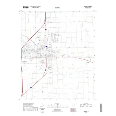
2019 Map of Plainview
USGS Topo · Published 2019About this map
Plainview serves as the primary hub of this High Plains landscape, characterized by its dense street grid and significant agricultural aviation infrastructure. The town's expansion is evident toward Seth Ward to the northeast, while the southern reaches are marked by the presence of Furguson and the Hale County Airport. For those tracing local history, the map provides precise locations for three distinct burial grounds situated near the city center: Plainview Memorial Park, the Independent Order of Odd Fellows Cem, and the original Plainview Cem. The terrain is generally flat, bisected by the natural course of Running Water Draw, which winds through the western and southern portions of the city. A complex network of farm-to-market roads and county lines, such as Co Rd 60 and FM 400, highlights the region's reliance on organized land parcels and transport.
Find a feature on this map
164 named features on this map. Tap any name to fly to it.
Don’t see what you’re looking for? This feature index may not catch every label — zoom into the map to look around manually.
Map Details
Editions of this 2019 Plainview Map
This is the sole edition of this map. No revisions or reprints were ever made.
Other maps of this area

1954 · Plainview
USGS Topo · 1:250,000

1958 · Plainview
USGS Topo · 1:250,000

1965 · Kress West
USGS Topo · 1:24,000

1965 · Wasson
USGS Topo · 1:24,000

1965 · Plainview
USGS Topo · 1:24,000

1968 · Happy Union
USGS Topo · 1:24,000

1968 · Plainview SE
USGS Topo · 1:24,000
1968 · Hale Center
USGS Topo · 1:24,000

1968 · Aiken
USGS Topo · 1:24,000

1969 · Kress East
USGS Topo · 1:24,000