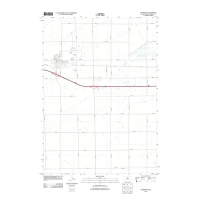
2012 Map of Plankinton
USGS Topo · Published 2012About this map
Plankinton sits as the central hub of this Aurora County landscape, positioned along the corridor of Interstate 90 and Co HWY-34. The town's grid is clearly defined by historical thoroughfares like N Main St and Kimball St, while its surrounding rural township is marked by a legacy of local memorial sites. Four distinct cemeteries serve the community: Plankinton Cem just south of town, Saint Johns Cem and Mizpah Cem to the north, and Dudley Cem in the southeastern quadrant. The topography is influenced by natural water features such as Fish Lake in the northeast and the winding path of Enemy Cr near the southern boundary. This 2012 survey documents the transition from a traditional small-town layout to the modern arterial road network that connects these agricultural lands.
Find a feature on this map
39 named features on this map. Tap any name to fly to it.
Don’t see what you’re looking for? This feature index may not catch every label — zoom into the map to look around manually.
Map Details
Editions of this 2012 Plankinton Map
This is the sole edition of this map. No revisions or reprints were ever made.
Other maps of this area

1899 · Mitchell
USGS Topo · 1:125,000

1942 · Crow Lake
USGS Topo · 1:62,500

1955 · Mitchell
USGS Topo · 1:250,000

1959 · Mitchell
USGS Topo · 1:250,000

1979 · Crystal Lake
USGS Topo · 1:24,000

1979 · Aurora Center
USGS Topo · 1:24,000

1979 · Storla SW
USGS Topo · 1:24,000

1979 · Storla
USGS Topo · 1:24,000

1980 · Stickney
USGS Topo · 1:24,000

1980 · Old Stickney Lake
USGS Topo · 1:24,000
Featured Places
- Plankinton, SD
- Hopper Township, SD
- Plankinton Township, SD
- Pleasant Lake Township, SD
- Dudley Township, SD