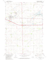
1980 Map of Plankinton
USGS Topo · Published 1980About this map
Plankinton serves as the focal point of this South Dakota landscape, characterized by the intersection of early transportation and civic institutions. The town is situated along the Chicago Milwaukee St Paul and Pacific railroad, reflecting the vital rail connections that supported the region's agricultural economy. On the outskirts of the settlement, the State Training Sch and the local Fairground point to the community's role as a regional hub for education and public gathering.
Find a feature on this map
23 named features on this map. Tap any name to fly to it.
Don’t see what you’re looking for? This feature index may not catch every label — zoom into the map to look around manually.
Map Details
Editions of this 1980 Plankinton Map
This is the sole edition of this map. No revisions or reprints were ever made.
Other maps of this area

1899 · Mitchell
USGS Topo · 1:125,000

1942 · Crow Lake
USGS Topo · 1:62,500

1955 · Mitchell
USGS Topo · 1:250,000

1959 · Mitchell
USGS Topo · 1:250,000

1979 · Crystal Lake
USGS Topo · 1:24,000

1979 · Aurora Center
USGS Topo · 1:24,000

1979 · Storla SW
USGS Topo · 1:24,000

1979 · Storla
USGS Topo · 1:24,000

1980 · Stickney
USGS Topo · 1:24,000

1980 · Old Stickney Lake
USGS Topo · 1:24,000
Featured Places
- Plankinton, SD
- Plankinton Township, SD
- Pleasant Lake Township, SD
- Dudley Township, SD
- Hopper Township, SD