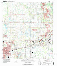
1994 Map of Plant City East
USGS Topo · Published 2000About this map
Plant City stands as a busy hub of transit and agriculture on the Hillsborough-Polk county line, anchored by its historic core around Baker St and the Courthouse. The landscape transitions from the urban density of Plant City to the wetlands of Wiggins Prairie and the winding course of Itchepackesassa Creek. Notable industrial and civic footprints include a Former Mine south of the city and the sprawl of Hillsborough Community College. Transit infrastructure is prominent, with the CSX Transportation rail line and the parallel North and South Frontage Roads serving as primary east-west corridors. Smaller communities such as Mt Enon and Youmans dot the central plains, while numerous fish hatcheries take advantage of the high water table and numerous small lakes like Lester Lake and Galloway Lake.
Find a feature on this map
54 named features on this map. Tap any name to fly to it.
Don’t see what you’re looking for? This feature index may not catch every label — zoom into the map to look around manually.
Map Details
Editions of this 1994 Plant City East Map
This is the sole edition of this map. No revisions or reprints were ever made.
Other maps of this area

1944 · Plant City
USGS Topo · 1:31,680

1944 · Providence
USGS Topo · 1:31,680

1944 · Lakeland
USGS Topo · 1:31,680

1944 · Antioch
USGS Topo · 1:31,680

1944 · Socrum
USGS Topo · 1:31,680

1947 · Zephyrhills
USGS Topo · 1:24,000

1949 · Mulberry
USGS Topo · 1:24,000

1950 · Mulberry
USGS Topo · 1:24,000

1955 · Nichols
USGS Topo · 1:24,000

1955 · Dover
USGS Topo · 1:24,000