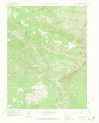
1965 Map of Platte Canyon
USGS Topo · Published 1967About this map
South Platte marks the confluence of mountain waters where the North Fork South Platte River joins the main stem amidst the rugged peaks of the Pike National Forest. In the mid-1960s, this area of Jefferson and Douglas Counties supported small mountain settlements such as Foxton, Critchell, and Longview, connected by winding roads and several river crossings. The landscape is defined by massive granite formations like Dome Rock, Chair Rocks, and Eagle Rock, while high peaks including Sheep Mountain and Goat Mountain tower over the narrow canyons. Evidence of local industry appears in several quarries, including the Little Patsy Quarry, while the Sampson Community Club and the Top of the World Picnic Area suggest a established community and recreational presence. Surveyors noted critical infrastructure of the era, including a Radio Tower, the Platte Canyon No 10 landmark, and multiple gaging stations monitoring the river's flow.
Find a feature on this map
45 named features on this map. Tap any name to fly to it.
Don’t see what you’re looking for? This feature index may not catch every label — zoom into the map to look around manually.
Map Details
Editions of this 1965 Platte Canyon Map
3 editions found
Other maps of this area

1893 · Platte Canyon
USGS Topo · 1:125,000

1899 · West Denver
USGS Topo · 1:125,000

1942 · Littleton
USGS Topo · 1:31,680

1945 · Indian Hills
USGS Topo · 1:31,680

1945 · Platte Canyon
USGS Topo · 1:24,000

1945 · Pine
USGS Topo · 1:24,000

1945 · Kassler
USGS Topo · 1:24,000

1948 · Kassler
USGS Topo · 1:24,000

1948 · Pine
USGS Topo · 1:24,000

1948 · Platte Canyon
USGS Topo · 1:24,000