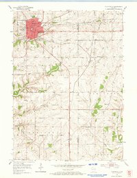
1952 Map of Platteville
USGS Topo · Published 1974About this map
Platteville serves as the regional hub in this early 1950s survey, defined by its educational institutions and industrial roots. The town center is anchored by Pioneer State College and the Wis Inst of Tech, while the surrounding landscape of Smelser and Elk Grove reveals a complex network of zinc and lead mining history. Numerous operations, including the Acme Mine and Homestead Mine, dot the countryside alongside expansive Mine Dumps, indicating the area's mineral importance. The transition from rail to road is visible where the Chicago Milwaukee St Paul and Pacific and the Chicago and North Western railroads cross the agricultural terrain. Rural life is meticulously documented through small settlements like Ipswich and Bigpatch, and several localized schoolhouses such as Woodchuck Sch and Robbins Sch.
Find a feature on this map
44 named features on this map. Tap any name to fly to it.
Don’t see what you’re looking for? This feature index may not catch every label — zoom into the map to look around manually.
Map Details
Editions of this 1952 Platteville Map
2 editions found
Other maps of this area

1900 · Lancaster
USGS Topo · 1:125,000

1902 · Mineral Point
USGS Topo · 1:125,000

1904 · Lancaster
USGS Topo · 1:125,000

1908 · Lancaster
USGS Topo · 1:125,000

1952 · Platteville
USGS Topo · 1:24,000

1952 · Rewey
USGS Topo · 1:24,000

1952 · Cuba City
USGS Topo · 1:24,000

1952 · Belmont
USGS Topo · 1:24,000

1952 · New Diggings
USGS Topo · 1:24,000

1952 · Mifflin
USGS Topo · 1:24,000