
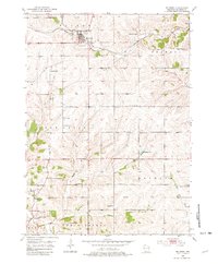
1952 Map of Belmont
USGS Topo · Published 1954About this map
Belmont stands as the primary hub in this southwest Wisconsin landscape, situated where the Chicago Milwaukee ST Paul And Pacific railroad cuts across the headwaters of Bonner Branch. The terrain is defined by a dense network of country schools and rural churches, reflecting the distributed agricultural and mining communities of the early 1950s. Toward the south, the economy shifts toward heavy extraction, evidenced by the Leo V Mine, Liberty Mine, and numerous quarries near Meekers Grove and Jenkinsville. The survey captures a mid-century moment before significant school consolidation, preserving the locations of the Strawberry Sch, Bashford Sch, and Vickers Sch. This detailed topography also traces the winding courses of the Pecatonica River and Galena River as they drain the dissected uplands of Lafayette County.
Find a feature on this map
35 named features on this map. Tap any name to fly to it.
Don’t see what you’re looking for? This feature index may not catch every label — zoom into the map to look around manually.
Map Details
Editions of this 1952 Belmont Map
2 editions found
Other maps of this area

1902 · Mineral Point
USGS Topo · 1:125,000

1952 · Shullsburg
USGS Topo · 1:24,000

1952 · Platteville
USGS Topo · 1:24,000

1952 · Calamine
USGS Topo · 1:24,000

1952 · Rewey
USGS Topo · 1:24,000

1952 · Mineral Point
USGS Topo · 1:24,000

1952 · Cuba City
USGS Topo · 1:24,000

1952 · New Diggings
USGS Topo · 1:24,000

1952 · Mifflin
USGS Topo · 1:24,000

1959 · Dubuque
USGS Topo · 1:250,000