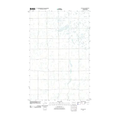
2011 Map of Plaza NE
USGS Topo · Published 2011About this map
Glacial prairie potholes and small wetlands dominate this section of Ward County, where the terrain is defined by a dense network of seasonal water bodies and marshes. The landscape is structured by a rigid section-line road system, including 386th St Nw and 324th St Nw, which carve through the undulating wetland basins. This map illustrates the agricultural character of the region, where roads like 4th Ave Nw and 93rd Ave Sw provide the primary access to farmsteads scattered among the numerous unnamed sloughs. The lack of concentrated settlements or commercial centers emphasizes the rural, dispersed nature of this North Dakota prairie environment, where land use is dictated by the natural drainage patterns of the Missouri Plateau.
Find a feature on this map
13 named features on this map. Tap any name to fly to it.
Don’t see what you’re looking for? This feature index may not catch every label — zoom into the map to look around manually.
Map Details
Editions of this 2011 Plaza NE Map
This is the sole edition of this map. No revisions or reprints were ever made.
Other maps of this area

1954 · Minot
USGS Topo · 1:250,000

1958 · Minot
USGS Topo · 1:250,000

1980 · Minot
USGS Topo · 1:100,000

1980 · Plaza SE
USGS Topo · 1:24,000

1980 · Rice Lake NW
USGS Topo · 1:24,000

1980 · Tagus SE
USGS Topo · 1:24,000
1980 · Plaza
USGS Topo · 1:24,000
1980 · Berthold
USGS Topo · 1:24,000
1980 · Underdahl Lake
USGS Topo · 1:24,000

1980 · Tagus
USGS Topo · 1:24,000