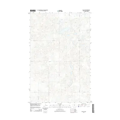
2014 Map of Plaza NE
USGS Topo · Published 2014About this map
Ward County's glaciated prairie landscape is defined here by a dense network of seasonal wetlands and small lakes, set against the rigid geometry of the Public Land Survey System. The area is characterized by the "pothole" topography typical of the North Dakota plains, where numerous unnamed basins catch runoff across the high ground. A meticulously planned grid of rural roads, including 338th St Sw and 54th Ave Sw, provides the primary infrastructure for the agricultural operations that dominate this terrain. This 2014 survey captures the precise elevation contours of these depressions, illustrating how the modern road network, such as 352nd St Sw and 93rd Ave Sw, navigates the complex hydrology of the prairie while maintaining the straight-line heritage of Western settlement patterns.
Find a feature on this map
12 named features on this map. Tap any name to fly to it.
Don’t see what you’re looking for? This feature index may not catch every label — zoom into the map to look around manually.
Map Details
Editions of this 2014 Plaza NE Map
This is the sole edition of this map. No revisions or reprints were ever made.
Other maps of this area

1954 · Minot
USGS Topo · 1:250,000

1958 · Minot
USGS Topo · 1:250,000

1980 · Minot
USGS Topo · 1:100,000

1980 · Plaza SE
USGS Topo · 1:24,000

1980 · Rice Lake NW
USGS Topo · 1:24,000

1980 · Tagus SE
USGS Topo · 1:24,000
1980 · Plaza
USGS Topo · 1:24,000
1980 · Berthold
USGS Topo · 1:24,000
1980 · Underdahl Lake
USGS Topo · 1:24,000

1980 · Tagus
USGS Topo · 1:24,000