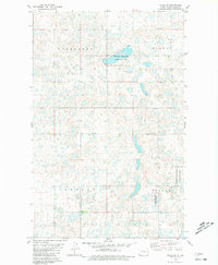
1980 Map of Plaza NE
USGS Topo · Published 1981About this map
Evergreen, Mandan, Shealey, and Tolgen townships divide this prairie landscape in Ward County during the early 1980s. The terrain is defined by an intricate network of wetlands and small water bodies, many of which are protected within the National Waterfowl Production Area. This conservation focus reflects the region's importance as part of the migratory flyway, where glacial depressions form critical habitat. Apart from the natural features, the human imprint is sparse, characterized primarily by section-line roads and an occasional Gravel Pit near the eastern boundary. This survey provides a clear view of the rural township structure and the preservation of waterfowl breeding grounds before modern agricultural intensifications further altered the northern plains.
Find a feature on this map
6 named features on this map. Tap any name to fly to it.
Don’t see what you’re looking for? This feature index may not catch every label — zoom into the map to look around manually.
Map Details
Editions of this 1980 Plaza NE Map
This is the sole edition of this map. No revisions or reprints were ever made.
Other maps of this area

1954 · Minot
USGS Topo · 1:250,000

1958 · Minot
USGS Topo · 1:250,000

1980 · Minot
USGS Topo · 1:100,000

1980 · Plaza SE
USGS Topo · 1:24,000

1980 · Rice Lake NW
USGS Topo · 1:24,000

1980 · Tagus SE
USGS Topo · 1:24,000
1980 · Plaza
USGS Topo · 1:24,000
1980 · Berthold
USGS Topo · 1:24,000
1980 · Underdahl Lake
USGS Topo · 1:24,000

1980 · Tagus
USGS Topo · 1:24,000