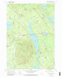
1963 Map of Pleasant Mtn
USGS Topo · Published 1988About this map
Moose Pond dominates the central valley of this Western Maine landscape, carved by the steep slopes of Pleasant Mountain and Black Mtn. The 1963 field check records a region defined by its rural cemeteries and scattered upland settlements like West Bridgton and Liberty Corner. This survey provides significant value for genealogists, as it meticulously identifies numerous family burial grounds including Hio Ridge Cem, Strout Cem, and Deering Cem. The land use of the era is evident in the network of woods roads and trails leading to landmarks like the Lookout Tower atop the mountain. The mapping also reveals the early 1960s state of lakes such as Kezar Pond and Highland Lake, before decades of modern lakeside development altered these shorelines.
Find a feature on this map
67 named features on this map. Tap any name to fly to it.
Don’t see what you’re looking for? This feature index may not catch every label — zoom into the map to look around manually.
Map Details
Editions of this 1963 Pleasant Mtn Map
3 editions found
Other maps of this area

1896 · Norway
USGS Topo · 1:62,500

1896 · Sebago
USGS Topo · 1:62,500

1909 · Fryeburg
USGS Topo · 1:62,500

1910 · Kezar Falls
USGS Topo · 1:48,000

1911 · Fryeburg
USGS Topo · 1:62,500

1911 · Kezar Falls
USGS Topo · 1:62,500

1941 · Fryeburg
USGS Topo · 1:62,500

1942 · Sebago Lake
USGS Topo · 1:62,500

1943 · Sebago Lake
USGS Topo · 1:62,500

1946 · Norway
USGS Topo · 1:62,500