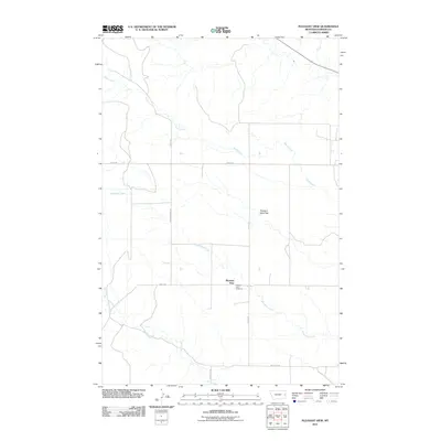
2011 Map of Pleasant View
USGS Topo · Published 2011About this map
Pleasant View occupies a high point on the Dawson County landscape, centered around a local crossroads in the early 21st century. The map reveals a rural community defined by its water sources and topography, notably the broad Pleasant View Flat that stretches across the central terrain. Waterways such as Sand Creek, Whoopup Creek, and Clear Creek carve through the prairie, dictating the placement of the sparse road network. A primary point of local history is the Pleasant View Cemetery, situated near the junction of Pleasant View Rd and Road 244. The rectangular grid of section lines and gravel routes like Whoopup Rd and Road 238 reflect a landscape structured for ranching and agriculture, where settlements are small and distances between landmarks are significant.
Find a feature on this map
12 named features on this map. Tap any name to fly to it.
Don’t see what you’re looking for? This feature index may not catch every label — zoom into the map to look around manually.
Map Details
Editions of this 2011 Pleasant View Map
This is the sole edition of this map. No revisions or reprints were ever made.
Other maps of this area

1909 · Glendive
USGS Topo · 1:250,000

1953 · Miles City
USGS Topo · 1:250,000

1954 · Glendive
USGS Topo · 1:250,000

1957 · Miles City
USGS Topo · 1:250,000

1957 · Glendive
USGS Topo · 1:250,000

1958 · Miles City
USGS Topo · 1:250,000

1958 · Glendive
USGS Topo · 1:250,000

1967 · Marsh
USGS Topo · 1:24,000

1967 · Hoyt
USGS Topo · 1:24,000
1967 · Forest Park
USGS Topo · 1:24,000