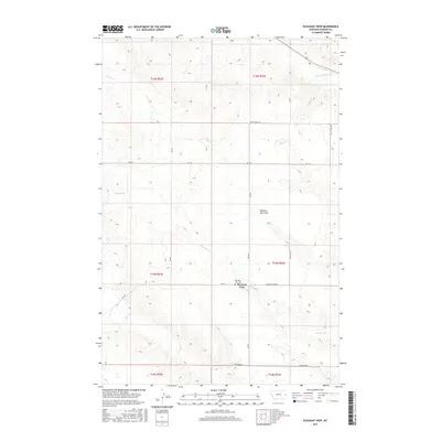
2017 Map of Pleasant View
USGS Topo · Published 2017About this map
Pleasant View sits at the heart of this Dawson County landscape, where the high plains terrain is defined by wide expanses like Pleasant View Flat. The 2017 survey details a rural network of farm roads and drainage systems, with the winding paths of Whoopup Cr and Sand Cr cutting through the prairie. Local history is anchored by the Pleasant View Cem, located near the junction of RD 244 and RD 247. The map illustrates a contemporary view of eastern Montana's ranching country, where the vast township and range grids of t15n r54e and t16n r54e organize the land. Other notable water features include Clear Cr in the southwest and Upper Sevenmile Cr in the northeast, highlighting the subtle but essential hydrology of this semi-arid region.
Find a feature on this map
22 named features on this map. Tap any name to fly to it.
Don’t see what you’re looking for? This feature index may not catch every label — zoom into the map to look around manually.
Map Details
Editions of this 2017 Pleasant View Map
This is the sole edition of this map. No revisions or reprints were ever made.
Other maps of this area

1909 · Glendive
USGS Topo · 1:250,000

1953 · Miles City
USGS Topo · 1:250,000

1954 · Glendive
USGS Topo · 1:250,000

1957 · Miles City
USGS Topo · 1:250,000

1957 · Glendive
USGS Topo · 1:250,000

1958 · Miles City
USGS Topo · 1:250,000

1958 · Glendive
USGS Topo · 1:250,000

1967 · Marsh
USGS Topo · 1:24,000

1967 · Hoyt
USGS Topo · 1:24,000
1967 · Forest Park
USGS Topo · 1:24,000