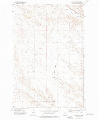
1972 Map of Pleasant View
USGS Topo · Published 1975About this map
Pleasant View Flat defines the open landscape of Dawson County in the early 1970s, where agricultural plateaus meet the intricate drainages of the Burlington Northern railroad corridor. The small settlement of Pleasant View sits at the intersection of local thoroughfares like North Pleasant View Road, serving as a central point for the surrounding rural homesteads. This era shows a landscape transitioning between traditional ranching and burgeoning energy extraction, evidenced by scattered Oil Wells and a crossing Pipeline.
Find a feature on this map
14 named features on this map. Tap any name to fly to it.
Don’t see what you’re looking for? This feature index may not catch every label — zoom into the map to look around manually.
Map Details
Editions of this 1972 Pleasant View Map
This is the sole edition of this map. No revisions or reprints were ever made.
Other maps of this area

1909 · Glendive
USGS Topo · 1:250,000

1953 · Miles City
USGS Topo · 1:250,000

1954 · Glendive
USGS Topo · 1:250,000

1957 · Miles City
USGS Topo · 1:250,000

1957 · Glendive
USGS Topo · 1:250,000

1958 · Miles City
USGS Topo · 1:250,000

1958 · Glendive
USGS Topo · 1:250,000

1967 · Marsh
USGS Topo · 1:24,000

1967 · Hoyt
USGS Topo · 1:24,000
1967 · Forest Park
USGS Topo · 1:24,000