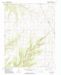
1994 Map of Pleasant View
USGS Topo · Published 1994About this map
Pleasant View and the surrounding high mesas of Montezuma County are defined by a complex network of deep drainage systems and early water management infrastructure. In this 1990s landscape, the terrain is deeply incised by Little Cahone Canyon, Hovenweep Canyon, and Sandstone Canyon, which drop away from the agricultural flats. The presence of several Canals, an extensive Aqueduct system, and facilities like the Pleasant View Pumping Sta and Ruin Canyon Pumping Sta illustrate the intensive effort to move water across this arid high-desert environment. Scattered Gas Wells indicate the region's energy development, while isolated landmarks such as a lone Grave and various radio towers stand as quiet sentinels on the plateaus above Negro Canyon and Woods Canyon. This map provides a detailed view of the interaction between natural canyon geology and the engineered systems required to sustain local life.
Find a feature on this map
17 named features on this map. Tap any name to fly to it.
Don’t see what you’re looking for? This feature index may not catch every label — zoom into the map to look around manually.
Map Details
Editions of this 1994 Pleasant View Map
This is the sole edition of this map. No revisions or reprints were ever made.
Other maps of this area

1956 · Cortez
USGS Topo · 1:250,000

1957 · Moqui NW
USGS Topo · 1:24,000

1957 · Cedar 3 NW
USGS Topo · 1:24,000

1957 · Cedar 3 SW
USGS Topo · 1:24,000

1958 · Cortez
USGS Topo · 1:250,000

1959 · Cortez
USGS Topo · 1:250,000

1962 · Cortez
USGS Topo · 1:250,000

1965 · Cahone
USGS Topo · 1:24,000

1965 · Woods Canyon
USGS Topo · 1:24,000

1965 · Yellow Jacket
USGS Topo · 1:24,000