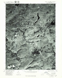
1976 Map of Pleasant View Summit
USGS Topo · Published 1979About this map
Lehigh River corridor views within the Luzerne county area are revealed in this 1976 orthophotograph, capturing the high-plateau landscape before major modern developments altered the character of the terrain. The settlement of Stoddartsville sits at the southern edge of the sheet, where the river winds through thick forest cover toward its lower reaches. The aerial imagery highlights the dense woodlands surrounding the Pleasant View Summit and the dark waters of Bear Lake in the northeastern quadrant. Local transportation and settlement patterns are anchored by small communities like Shades Glen, providing a stark visual record of how roads and clearings were etched into the natural drainage basins of Bear Creek. The orthophoto format provides a unique perspective on land usage and forest density that traditional line-drawn maps often obscure.
Find a feature on this map
8 named features on this map. Tap any name to fly to it.
Don’t see what you’re looking for? This feature index may not catch every label — zoom into the map to look around manually.
Map Details
Editions of this 1976 Pleasant View Summit Map
This is the sole edition of this map. No revisions or reprints were ever made.
Other maps of this area

1889 · Scranton
USGS Topo · 1:62,500

1891 · Wilkesbarre
USGS Topo · 1:62,500

1891 · Scranton
USGS Topo · 1:62,500

1893 · Pittston
USGS Topo · 1:62,500

1893 · Scranton
USGS Topo · 1:62,500

1894 · Wilkesbarre
USGS Topo · 1:62,500

1922 · Stoddartsville
USGS Topo · 1:62,500

1924 · Stoddartsville
USGS Topo · 1:62,500

1943 · Scranton
USGS Topo · 1:125,000

1943 · Stoddartsville
USGS Topo · 1:62,500
Featured Places
- Thornhurst Township, PA
- Kidder Township, PA
- Buck Township, PA
- Tobyhanna Township, PA
- Pleasant View Summit, Bear Creek Township