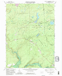
1992 Map of Pleasant View Summit
USGS Topo · Published 1995About this map
State Game Lands No 91 and the Lackawanna State Forest dominate this landscape, preserving a vast expanse of the Poconos as it appeared in the late twentieth century. The map centers on the small settlement of Pleasant View Summit, where high elevations give way to complex drainage systems including Painter Creek and Bear Creek. To the south, the historic Stoddartsville sits along the Lehigh River, a site of early industrial significance. A distinct industrial and logistical imprint is visible through the Bear Creek Railroad Grade and several utility corridors, including a prominent Pipeline crossing the terrain. The geography is characterized by numerous wetlands and water bodies such as Bear Lake, Mud Pond, and Horseshoe Swamp, punctuated by high points like Bald Mtn and Big Pine Hill, which features a Lookout Tower.
Find a feature on this map
50 named features on this map. Tap any name to fly to it.
Don’t see what you’re looking for? This feature index may not catch every label — zoom into the map to look around manually.
Map Details
Editions of this 1992 Pleasant View Summit Map
This is the sole edition of this map. No revisions or reprints were ever made.
Other maps of this area

1889 · Scranton
USGS Topo · 1:62,500

1891 · Wilkesbarre
USGS Topo · 1:62,500

1891 · Scranton
USGS Topo · 1:62,500

1893 · Pittston
USGS Topo · 1:62,500

1893 · Scranton
USGS Topo · 1:62,500

1894 · Wilkesbarre
USGS Topo · 1:62,500

1922 · Stoddartsville
USGS Topo · 1:62,500

1924 · Stoddartsville
USGS Topo · 1:62,500

1943 · Scranton
USGS Topo · 1:125,000

1943 · Stoddartsville
USGS Topo · 1:62,500
Featured Places
- Thornhurst Township, PA
- Kidder Township, PA
- Buck Township, PA
- Tobyhanna Township, PA
- Pleasant View Summit, Bear Creek Township