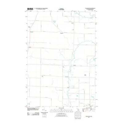
2011 Map of Pleasanton
USGS Topo · Published 2011About this map
Pleasanton and the surrounding township appear here as a landscape defined by an orderly grid of country roads and winding glacial waterways. The northern reach is shaped by the Betsie River and Glovers Lake, while the southern area transitions toward the settlement of Kaleva. Local history is preserved in sites like the Pleasanton Township Cemetery and the Springdale Cemetery, alongside the former Kilborn School. The topography is etched with numerous creeks, including Bear Creek and Little Bear Creek, which drain the lowlands between named junctions like Hale Corners and Big Four Corners. Modern recreational and community landmarks are also evident, from the Northern Michigan Dragway to the Crystal Forest Campground and Fuzzy Bear Campground. The road network, featuring routes like Glovers Lake Rd and Potter Rd, connects these scattered rural hubs across the Manistee County countryside.
Find a feature on this map
62 named features on this map. Tap any name to fly to it.
Don’t see what you’re looking for? This feature index may not catch every label — zoom into the map to look around manually.
Map Details
Editions of this 2011 Pleasanton Map
This is the sole edition of this map. No revisions or reprints were ever made.
Other maps of this area

1954 · Traverse City
USGS Topo · 1:250,000

1954 · Manitowoc
USGS Topo · 1:250,000

1956 · Onekama
USGS Topo · 1:62,500

1956 · Thompsonville
USGS Topo · 1:62,500

1956 · Frankfort
USGS Topo · 1:62,500

1957 · Copemish
USGS Topo · 1:62,500

1958 · Traverse City
USGS Topo · 1:250,000

1958 · Manitowoc
USGS Topo · 1:250,000

1976 · Frankfort SE
USGS Topo · 1:24,000

1976 · Onekama SE
USGS Topo · 1:24,000