
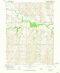
2011 Map of Pleasanton SE
USGS Topo · Published 2011About this map
Wood River meanders across the southern landscape of this Buffalo County survey, defining the agricultural and residential character of the Glenwood Park area. The township is structured by a rigid section grid of rural roads, including Antelope Rd and Pole Line Rd, which connect the small settlement of Prairie Center to the surrounding prairie. This area preserves essential community history through the presence of Saint Mary Cemetery and Prairie Center Cemetery, which serve as primary landmarks for local genealogists and historians. The drainage patterns of Dry Creek and Sand Creek cut through the geometric road network, illustrating how the natural hydrology of the plains continues to shape land use. Agricultural operations, such as the Moo Feedlot, are integrated into the grid, highlighting the modern cattle and farming economy that sustains these Nebraska communities.
Find a feature on this map
40 named features on this map. Tap any name to fly to it.
Don’t see what you’re looking for? This feature index may not catch every label — zoom into the map to look around manually.
Map Details
Editions of this 2011 Pleasanton SE Map
This is the sole edition of this map. No revisions or reprints were ever made.
Other maps of this area

1894 · Kearney
USGS Topo · 1:62,500

1894 · Minden
USGS Topo · 1:62,500

1896 · Kearney
USGS Topo · 1:125,000

1896 · Wood River
USGS Topo · 1:125,000

1955 · Grand Island
USGS Topo · 1:250,000

1957 · Grand Island
USGS Topo · 1:250,000

1958 · Grand Island
USGS Topo · 1:250,000

1962 · Newark
USGS Topo · 1:24,000

1962 · Riverdale
USGS Topo · 1:24,000
1962 · Pleasanton NW
USGS Topo · 1:24,000