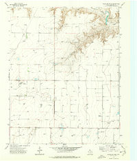
1974 Map of Pleasure Pond
USGS Topo · Published 1977About this map
Coldwater Creek cuts through the northern landscape of this Sherman County quadrangle, leading to the small reservoir of Pleasure Pond. This 1970s survey captures a landscape defined by industrial extraction in the Texas Panhandle, where a dense network of energy infrastructure dominates the plains. The map is heavily punctuated by numerous Oil Well and Gas Well sites, connected by a web of unimproved roads and pipelines that illustrate the intensity of local petroleum and natural gas production during this era. Apart from the energy sector, a Gravel Pit near the creek breaks the surface, while the surrounding terrain is marked by benchmark elevations and scattered watering tanks, reflecting the dual reliance on mineral wealth and traditional ranching in this high-plains environment.
Find a feature on this map
5 named features on this map. Tap any name to fly to it.
Don’t see what you’re looking for? This feature index may not catch every label — zoom into the map to look around manually.
Map Details
Editions of this 1974 Pleasure Pond Map
This is the sole edition of this map. No revisions or reprints were ever made.
Other maps of this area

1954 · Perryton
USGS Topo · 1:250,000

1958 · Perryton
USGS Topo · 1:250,000

1963 · Cactus East
USGS Topo · 1:24,000

1964 · Stevens SW
USGS Topo · 1:24,000

1965 · Spurlock Chapel
USGS Topo · 1:24,000

1972 · Capps Switch
USGS Topo · 1:24,000

1972 · Sunray
USGS Topo · 1:24,000

1974 · Stevens SE
USGS Topo · 1:24,000

1974 · Sunray 1 SW
USGS Topo · 1:24,000

1974 · Capps Switch NW
USGS Topo · 1:24,000