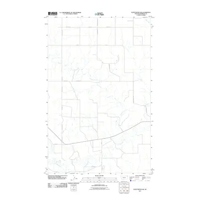
2011 Map of Plentywood SW
USGS Topo · Published 2011About this map
Big Muddy Creek defines the southern reaches of this Sheridan County landscape, where the prairie is etched by a network of seasonal coulees and drainage ways. The geography reflects a sparsely populated agricultural region, anchored by the location of S Archer and the named area of Sitting Bull along the creek bottoms. Transportation in the early 21st century relied on a grid of rural routes named for local landmarks and families, including Chalk Butte Rd and Hendrickson Hill Rd. The map also traces the winding course of Plentywood Creek and McCoy Creek as they move through the undulating terrain near Firehill. This survey documents a quiet corner of Montana's northeast, capturing the relationship between isolated rural residences and the vital water sources that dictate the placement of roads and homesteads.
Find a feature on this map
18 named features on this map. Tap any name to fly to it.
Don’t see what you’re looking for? This feature index may not catch every label — zoom into the map to look around manually.
Map Details
Editions of this 2011 Plentywood SW Map
This is the sole edition of this map. No revisions or reprints were ever made.
Other maps of this area

1950 · Shippe Canyon
USGS Topo · 1:24,000

1954 · Wolf Point
USGS Topo · 1:250,000

1958 · Wolf Point
USGS Topo · 1:250,000

1983 · Plentywood NW
USGS Topo · 1:24,000

1983 · Outlook
USGS Topo · 1:24,000

1983 · Kisler Butte
USGS Topo · 1:24,000

1983 · Archer
USGS Topo · 1:24,000

1983 · Plentywood
USGS Topo · 1:24,000

1983 · Raymond
USGS Topo · 1:24,000
1983 · Soo NE
USGS Topo · 1:24,000