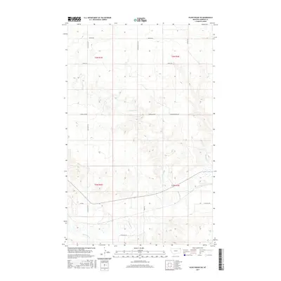
2017 Map of Plentywood SW
USGS Topo · Published 2017About this map
Big Muddy Creek defines the lower drainage of this prairie landscape in Sheridan County, winding through the southern portion of the quadrangle. The terrain is structured by a grid of rural routes including Tobiason Rd, Chalk Butte Rd, and Hendrickson Hill Rd, reflecting the long-established Public Land Survey System divisions of T35N and T36N. The settlement at Archer sits along the southern transit corridor, marking a focal point for local connectivity near the confluence of Pond Creek and the larger river system. Significant local watercourses like Plentywood Creek and McCoy Creek underscore the importance of water management in this agricultural region, evidenced further by landmarks like Carroll Dam Rd. The name Sitting Bull Rd provides a clear link to the area's indigenous history and the cultural memory of the Northern Plains.
Find a feature on this map
19 named features on this map. Tap any name to fly to it.
Don’t see what you’re looking for? This feature index may not catch every label — zoom into the map to look around manually.
Map Details
Editions of this 2017 Plentywood SW Map
This is the sole edition of this map. No revisions or reprints were ever made.
Other maps of this area

1950 · Shippe Canyon
USGS Topo · 1:24,000

1954 · Wolf Point
USGS Topo · 1:250,000

1958 · Wolf Point
USGS Topo · 1:250,000

1983 · Plentywood NW
USGS Topo · 1:24,000

1983 · Outlook
USGS Topo · 1:24,000

1983 · Kisler Butte
USGS Topo · 1:24,000

1983 · Archer
USGS Topo · 1:24,000

1983 · Plentywood
USGS Topo · 1:24,000

1983 · Raymond
USGS Topo · 1:24,000
1983 · Soo NE
USGS Topo · 1:24,000