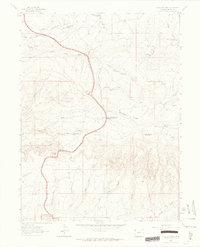
1962 Map of Plug Hat Rock
USGS Topo · Published 1965About this map
Dinosaur National Monument occupies the southern reach of this landscape, where the high-elevation terrain is defined by dramatic geological features like Plug Hat Rock and the long expanse of Buckwater Ridge. The 1962 topography shows a remote ranching and grazing environment marked by isolated outposts such as Haslem Cabin, Morgan Cabin, and Fletcher Cabin. These structures, along with several water sources like Blue Mountain Spring No 1 and Basin Springs, illustrate the historical reliance on scattered mountain springs to support life in this arid part of Moffat County. The winding route of Harpers Corner Road provides the primary access through the plateaus, passing near Escalante Overlook. Below the ridges, deep drainage systems like Bull Canyon and Dripping Rock Creek carve through the earth, while scattered drill holes hint at the mineral exploration of the mid-century era.
Find a feature on this map
40 named features on this map. Tap any name to fly to it.
Don’t see what you’re looking for? This feature index may not catch every label — zoom into the map to look around manually.
Map Details
Editions of this 1962 Plug Hat Rock Map
This is the sole edition of this map. No revisions or reprints were ever made.
Other maps of this area

1885 · Ashley
USGS Topo · 1:250,000

1907 · Rangely
USGS Topo · 1:125,000

1907 · Jensen
USGS Topo · 1:125,000

1910 · Jensen
USGS Topo · 1:125,000

1910 · Rangely
USGS Topo · 1:125,000

1954 · Hells Canyon
USGS Topo · 1:24,000

1954 · Vernal
USGS Topo · 1:250,000

1955 · Stuntz Reservoir
USGS Topo · 1:24,000

1958 · Vernal
USGS Topo · 1:250,000

1960 · Vernal
USGS Topo · 1:250,000