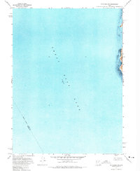
1972 Map of Plug Peak NE
USGS Topo · Published 1973About this map
The Great Salt Lake dominates this 1970s orthophotomap, showing the expansive water surface at a recorded elevation of 4200 feet based on 1953 data. Unlike traditional topographic maps, this edition uses an orthophotomosaic base to show the actual texture of the water and shoreline. Along the eastern edge, the steep, rocky terrain of Antelope Island rises sharply from the salt water, providing a clear visual record of the land-water interface during this period. An indefinite boundary marks the aquatic border between Davis County and Tooele County, cutting diagonally across the lake. This survey is particularly notable for its underwater bathymetry, with soundings and underwater contours compiled from data provided by the U.S. Naval Reserve and the Utah Geological and Mineralogical Survey, offering a rare view of the lake bed's profile.
Find a feature on this map
4 named features on this map. Tap any name to fly to it.
Don’t see what you’re looking for? This feature index may not catch every label — zoom into the map to look around manually.
Map Details
Editions of this 1972 Plug Peak NE Map
This is the sole edition of this map. No revisions or reprints were ever made.
Other maps of this area

1885 · Tooele Valley
USGS Topo · 1:250,000

1952 · Antelope Island South
USGS Topo · 1:24,000

1953 · Tooele
USGS Topo · 1:250,000

1954 · Antelope Island
USGS Topo · 1:24,000

1954 · Antelope Island North
USGS Topo · 1:24,000

1954 · Brigham City
USGS Topo · 1:250,000

1955 · Tooele
USGS Topo · 1:250,000

1958 · Brigham City
USGS Topo · 1:250,000

1962 · Brigham City
USGS Topo · 1:250,000

1968 · Plug Peak SE
USGS Topo · 1:24,000