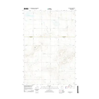
2014 Map of Plum Butte
USGS Topo · Published 2014About this map
Plum Butte rises as a prominent landmark in this section of the Great Plains, marking a rugged deviation in the landscape just south of the Hettinger and Adams County line. This 2014 survey reveals a transition between the northern high plains and the drainage basins of the Missouri River tributaries. The map documents the persistent agricultural grid, defined by a dense network of section-line roads like 21st St NE and 14th Ave NE, which navigate the undulating terrain and the seasonal watercourses of Timber Cr and Sheep Cr. In the northwest corner, the basin of Dry Lake serves as a reminder of the region's semi-arid hydrology, where large natural depressions often remain dry except during periods of high runoff. This map captures the intersection of traditional land divisions with the natural contours of the North Dakota badlands fringe.
Find a feature on this map
23 named features on this map. Tap any name to fly to it.
Don’t see what you’re looking for? This feature index may not catch every label — zoom into the map to look around manually.
Map Details
Editions of this 2014 Plum Butte Map
This is the sole edition of this map. No revisions or reprints were ever made.
Other maps of this area

1953 · Dickinson
USGS Topo · 1:250,000

1957 · Dickinson
USGS Topo · 1:250,000

1966 · Mott South
USGS Topo · 1:24,000

1969 · Burt
USGS Topo · 1:24,000

1969 · Bentley
USGS Topo · 1:24,000
1974 · Nason Hill
USGS Topo · 1:24,000
1974 · Plum Butte NE
USGS Topo · 1:24,000

1974 · Cedar Butte
USGS Topo · 1:24,000

1974 · Long Butte
USGS Topo · 1:24,000

1980 · Mott
USGS Topo · 1:100,000