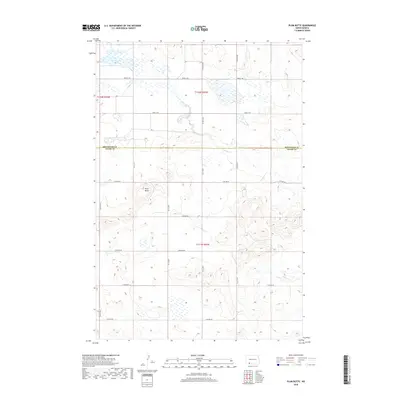
2018 Map of Plum Butte
USGS Topo · Published 2018About this map
Plum Butte stands as the primary topographic landmark on this rural landscape along the boundary of Hettinger and Adams Counties. The terrain is defined by a series of intermittent watercourses and seasonal basins, most notably Dry Lake in the northwest and the winding path of Timber Cr. The area is organized by a geometric grid of section roads including 14th Ave NE and 23rd St NE, illustrating the persistent influence of the Public Land Survey System on the modern North Dakota prairie. This document reflects a quiet agricultural interior where the natural drainage of Sheep Cr and various unnamed coulees shape the land use and movement through the township blocks of t132n r92w and t131n r92w.
Find a feature on this map
23 named features on this map. Tap any name to fly to it.
Don’t see what you’re looking for? This feature index may not catch every label — zoom into the map to look around manually.
Map Details
Editions of this 2018 Plum Butte Map
This is the sole edition of this map. No revisions or reprints were ever made.
Other maps of this area

1953 · Dickinson
USGS Topo · 1:250,000

1957 · Dickinson
USGS Topo · 1:250,000

1966 · Mott South
USGS Topo · 1:24,000

1969 · Burt
USGS Topo · 1:24,000

1969 · Bentley
USGS Topo · 1:24,000
1974 · Nason Hill
USGS Topo · 1:24,000
1974 · Plum Butte NE
USGS Topo · 1:24,000

1974 · Cedar Butte
USGS Topo · 1:24,000

1974 · Long Butte
USGS Topo · 1:24,000

1980 · Mott
USGS Topo · 1:100,000