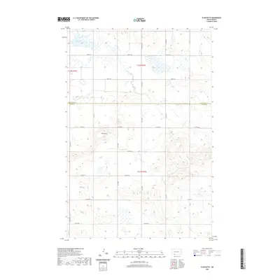
2020 Map of Plum Butte
USGS Topo · Published 2020About this map
Plum Butte rises as a prominent landmark in this open prairie landscape where Hettinger County meets Adams County in southwestern North Dakota. The terrain is defined by its seasonal hydrology, characterized by the intermittent flow of Timber Creek and Sheep Creek, alongside the shallow basin of Dry Lake. The map reveals a highly structured section-line road system, with routes such as 82nd Street SW and 22nd Avenue NE forming the grid for agricultural land use. This survey illustrates the persistent township and range organization that has shaped the Great Plains since the late 19th century, showing how the rural infrastructure adapts to the natural drainage patterns of the Missouri Plateau.
Find a feature on this map
22 named features on this map. Tap any name to fly to it.
Don’t see what you’re looking for? This feature index may not catch every label — zoom into the map to look around manually.
Map Details
Editions of this 2020 Plum Butte Map
This is the sole edition of this map. No revisions or reprints were ever made.
Other maps of this area

1953 · Dickinson
USGS Topo · 1:250,000

1957 · Dickinson
USGS Topo · 1:250,000

1966 · Mott South
USGS Topo · 1:24,000

1969 · Burt
USGS Topo · 1:24,000

1969 · Bentley
USGS Topo · 1:24,000
1974 · Nason Hill
USGS Topo · 1:24,000
1974 · Plum Butte NE
USGS Topo · 1:24,000

1974 · Cedar Butte
USGS Topo · 1:24,000

1974 · Long Butte
USGS Topo · 1:24,000

1980 · Mott
USGS Topo · 1:100,000